|
Walk Details » Short Walks Short Private Guided Walks - up to 4 hours on averageOur most popular walks are listed first. A range of times are indicated for the walks; the lower end of the time range is for fast walking by relatively fit people taking few stops along the way; the upper end of the time range is for casual walking by people of low-average fitness and taking plenty of time to stop on the walk. Please note that most of these walks - particularly the hill walks and hikes - are not on "trails". Most of these involve "off-trail" hiking ("bushwhacking") where there is no obvious path to follow; we will be using sheep tracks and occasionally faint tracks of eroded bog from other hill walkers. Booking is essential for all of the walks; email or call us for details and booking. The cost for an exclusive guided half-day hike (up to 4 hours) ranges from €160 (for shorter walks near Clifden, e.g. Omey, Connemara National Park, Mannin Bay, Erriseask) to €180 (for walks like Errisbeg, Inish Nee, Cashel Hill, Maumeen, Maumahoige, DerryClare Woods, Leenaun Valley). Walks that are far from Clifden will cost about €200 (e.g. Cong, Clonbur, Finny Hill). Maumahoge Mountain Lake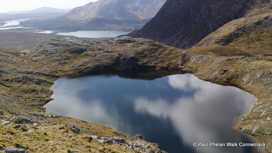 A moderately difficult three-four hour mountain hike in the wild Maumturks range. Features the spectacular mountain pass corrie lake of Maumahoige, a beautiful stream with waterfall and views of the mountain tops. Strong mountain boots with ankle support are necessary for the rough "off- trail" terrain of mountain heath, steep open hillside, bog and rock. The distance is about 6km with about 450m of total ascent. Requires good fitness, strong hiking boots with good ankle support and multi-layer outdoor clothes (including jacket, leggings, fleece, hat, gloves- no jeans) along with food, and water. Click here for Required Equipment. Derryclare Woods A two to four-hour walk in the special deciduous wood in the Inagh Valley near Recess. Features stunning woodland with deciduous and coniferous trees (many large native oaks), extensive lichens and moss, lakes and great views of the 12 Bens. Distance is about 10km, with only about 150m of climbing. The terrain is a mix of forest track, rough woodland and wet/rocky bogland so strong boots with good ankle support are needed. Also requires outdoor clothing, food and water. Derrigimlagh Walk
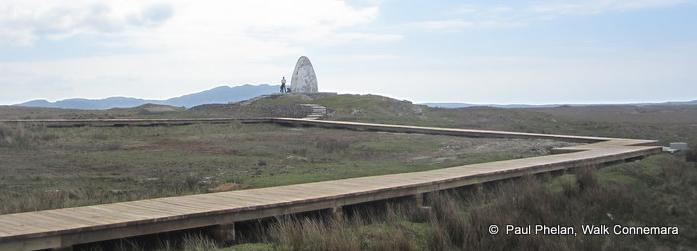
An easy three to four-hour flat hike exploring the historic Marconi site and part of the Roundstone Bog complex. The Wild Atlantic Way Signature Point of Derrigimlagh, or Derrygimla, is where the first ever transatlantic telecommunications took place and where Alcock & Brown's first non-stop transatlantic fight landed. The ruins of the Marconi telecommunications complex are located in the midst of the very special Roundstone Bog habit with its unique flora and fauna and multitude of lakes. Terrain includes gravel trails, boardwalks, and wet bogland. Paul Phelan brought the BBC Radio 4 Ramblings programme on this walk. You can listen to it online to learn more about this amazing location. Dogs Bay and Gurteen (Errisbeg) Peninsula
A two to four-hour coastal walk on the spectacular Gurteen/Gorteen peninsula near Roundstone and Ballyconneely which is a Discovery Point on the Wild Atlantic Way. Features several spectacular beaches with fine sands and dunes, extensive flora (including rare machair, vibrant lichens, along with seasonal heathers, sea holly, primroses and sea pinks), interesting rocks (granites, gabro), and wonderful sea/mountain views. Distance is ~6km with very little climbing. Terrain is mostly grassy and sandy, with some rocks. Maumeen Mountain Pass 
A two to four-hour hike on an ancient rocky trail to a spectacular mountain pass with significant history of pilgrimage and St. Patrick. Features dramatic mountain landscape, with lakes, bogland and stunning views. The distance is about 4km with about 170m of climbing, passing a Children’s Burial Ground. At the pass there are various religious structures including a small chapel, an open mass altar, stations of the cross and holy wells. The terrain is mainly rough stony trail through the bog. Requires a reasonable level of fitness and walking boots/shoes (preferably waterproof with ankle support), along with food, water and outdoor clothing (also preferably waterproof). Click here for Required Equipment. Roundstone Bog Wilderness: Lough na bhFaoileann (the lake of the Seagulls)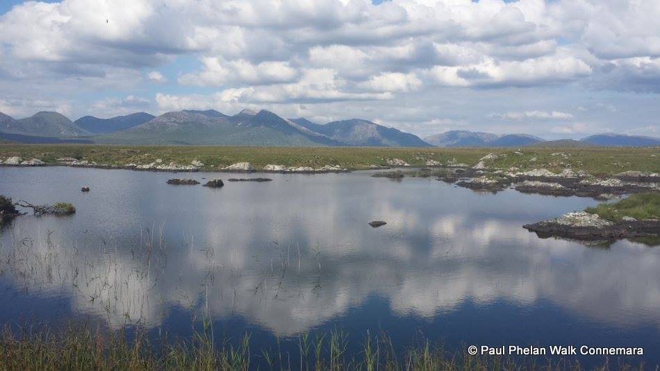
A moderate three to four-hour hike around one of the largest and wildest lakes of the spectacular Roundstone Bog complex (Lough na bhFaoileann; the lake of the Seagulls). A very special walk, featuring extensive rare bog habitat, a series of dramatic lakescapes overlooked by Errisbeg Hill and the towering Twelve Bens Mountains. Distance is about 9km with a small amount of gentle climbing. Terrain includes rough wet bogland (including quaking bog), sheep track, long grass and surfaced minor road. Requires strong hiking boots (preferably waterproof) with good ankle support and grip (trail shoes are not sufficient), along with food, water and outdoor layers (waterproof jacket and pants, hat, gloves and extra layers- no jeans). Diamond Hill Trail
A moderate two to four-hour climb to the top of
Diamond Hill along the
trail in the Connemara National Park. Distance is ~7km with ~500m of
total ascent. Features blanket bog, extensive heather, stunning views
of the mountains, islands and coastline and the possibility of
wildlife. There are some steep sections that require the use of hands.
Terrain includes stone steps, trail, and surfaced minor road. Boots and
outdoor clothing are preferable along with a reasonable level of
fitness. Also, it can be quite windy on top. Clifden Glen
An easy to moderate two to four-hour hike convenient to Clifden town. The landscape includes native oak woodland, river and open mountainside, with panoramic views of the 12 Bens and Roundstone Bog. Terrain includes rough trails, open hillside, sheep track. This walk is very flexible in terms of distance and difficulty and can be customised to suit your requirements. Errisbeg Hill Walk
A difficult three to five-hour hill walk near Roundstone. Features dramatic rocks, spectacular scenery including mountains, bog and coastline. Distance is about 7km with about 350m of climbing. Terrain includes steep open hillside, wet bog, sheep track and surfaced minor road. Requires good fitness and strong hiking boots with good ankle support, along with food, water and outdoor clothing. Works best with a car drop or else returns from the summit along same route; also, it can be extended into a loop including the Wild Atlantic Way Discovery Point Gorteen beach and peninsula (in the above picture) which requires a full day and usually takes 5-7 hours. Click here for Required Equipment. Omey Walk An easy two to four-hour hike around the beautiful tidal Omey island near Claddaghduff, which is a Discovery Point on the Wild Atlantic Way. Features beautiful sand, dunes, rare grassland, remains of an old church and houses, a holy well and birdlife. Distance is about 8km with some gentle climbing. Terrain includes beach, grass, track and surfaced minor road. This walk includes crossing the intertidal strand to this historic island. This walk can be done in sandals (and bare feet on the sand and some of the grass if you wish). Killary Harbour/Fjord Famine Walk A three to four-hour hike along the shore of Ireland’s only Fjord. Features dramatic coastal landscape, with the Fjord, the dramatic Mweelrea mountain, bogland and stunning views, passing the Killary Sheep Farm (working dogs and turf cutting). The terrain includes small road, rocky trail (Famine Relief Road) and boggy track. The distance is about 6km with about 140m of climbing (assuming a drop off and pick up). Requires a reasonable level of fitness and walking boots (preferably waterproof) with good ankle support, along with water and outdoor clothing (also preferably waterproof). Roundstone Bog Traverse
Mannin Bay
A two to three-hour
coastal walk along the Atlantic shoreline
south of Clifden. Features beautiful sandy beaches with seashells,
shell
middens, grassland and stunning seascapes. Distance is about 10km with
less
than 100m of total ascent. Terrain is a mix of grassland, beach, rocky
shore and
small road. Requires water, footwear with good grip and outdoor
clothing. Ludwig Wittgenstein Walk
A
two to three-hour hike to explore the locale and celebarate the art of the
eminent German philosopher Ludwig Wittgenstein. Ludwig produced some
fine work while residing here in 1948 and appears to have worked very
hard: Wittgenstein wrote how he "could only think clearly in the dark"
and how he had "found the last pool of darkness in Europe". The terrain
involves open hillside, track, trail and sealed road; strong walking
boots with ankle support are required. Features the Killlary Fjord, the
Famine trail, a pier, the former residence and a small spectacular pass. Cleggan and Claddaghduff
Clifden Walking Tour 
An easy two to three-hour stroll around the historical town and along the beautiful bay to Clifden Castle. Distance is about 5km with some gentle climbing. Terrain is mostly surfaced road, with a small amount of open field. Leenaun Valley Hike
Letterfrack WoodsA gentle two-hour walk around the historic Connemara village concentrating on the woods. Includes the Ellis Wood in which there are large numbers of bluebell and wild garlic plants (flowering dramatically in Spring). Includes hiking the woodland overlooking the Ballynakill Bay and visiting a 4,000 year old megalithic (court) tomb in the Connemara National Park. Requires walking boots with good grip and preferably ankle support and outdoor clothing.An Seanbhóthar (Cornamona to Clonbur)
Cong and Clonbur Forest Ramble 
A two to three-hour forest walk from Cong to Clonbur, through the special forests separating Loughs Corrib and Mask. The walk passes the Cong River, the Pigeon Hole cave, an impressive old castle and spectacular limestone pavement. Watch out for unusual trees and native Irish wildflowers. Walking shoes or boots would suit the terrain of forest tracks and minor surfaced roads. The distance is about 9km and is virtually flat. Works best with a car drop. Clonbur Woods
Lough Nafooey
Finny Hill
Lackavrea A three to four-hour hill climb near Maam Cross. Features spectacular views of the surrounding mountains (Maumturks, Joyce Country), bogland, Lough Corrib and the Maam Valley. The distance is about 7km with a total ascent of 460m. The terrain is mainly boggy open hillside; there is a steep rocky section requiring the use of hands. Requires strong hiking boots with ankle support and grip along with warm/waterproof outdoor layers, hat and gloves. Also bring some food and water. Oileain Finish - Tidal Island Walk A two to three-hour coastal walk around the immaculate tidal island
near Carna which is a Discovery Point on the Wild Atlantic
Way. This walk includes crossing the intertidal strand which
requires a very strong tide, that generally occurrs every two or three
months. However, even when a strong tide is forecast, the ultimate
strength of the tide depends on environmental factors which are beyond
our control (wind, pressure, pattern of tides in the deep ocean); thus
we cannot guarantee for certain that it will be safe to cross the
intertidal strand. Features superb sandy beaches, stunning seascapes,
rare
grassland, derelict stone houses, extensive shell middens and a holy
well. Distance is ~5km with almost no climbing. Terrain includes beach,
grass, track; there are no roads!
A two to three-hour coastal walk around the immaculate tidal island
near Carna which is a Discovery Point on the Wild Atlantic
Way. This walk includes crossing the intertidal strand which
requires a very strong tide, that generally occurrs every two or three
months. However, even when a strong tide is forecast, the ultimate
strength of the tide depends on environmental factors which are beyond
our control (wind, pressure, pattern of tides in the deep ocean); thus
we cannot guarantee for certain that it will be safe to cross the
intertidal strand. Features superb sandy beaches, stunning seascapes,
rare
grassland, derelict stone houses, extensive shell middens and a holy
well. Distance is ~5km with almost no climbing. Terrain includes beach,
grass, track; there are no roads!
South MayoSilver and White Strands This is an easy two to four-hour coastal walk over two spectacular beaches and the connecting headland, a Discovery Point on the Wild Atlantic Way. This is a very remote and unspoilt area, with beautiful sand dunes, rare machair and interesting archaeology including a very significant dog-whelk midden from where it is believed that early Irish settlers were extracting a rare pigment highly valued by North African Traders. The walk works best with a low tide. Erriff Bridge Woods A
gentle two to three-hour walk in the spectacular woods between Leenane and
Westport. Features stunning woodland with deciduous and coniferous
trees, fabulous moss, a fine river and great views of the mountains
(Sheefrey, Maumtrasna, Bengorm, Mweelrea Croagh Patrick). Distance is
about 10km, with only about 150m of climbing. Glenawough Lake and WoodsA gentle three to four-hour walk around the spectacular lake and deciduous wood between Leenane and Westport. Features stunning woodland (with deciduous and coniferous trees, fabulous moss), a fine river, a beautiful lake surrounded by mountains (Maumtrasna, Party, Sheefreys, Bengorm, Mweelrea Croagh Patrick). Distance is about 8km, with only about 270m of climbing. The terrain is open hill and forest so strong boots with ankle support are needed. Also requires outdoor clothing, food, and water. Click here for Required Equipment. Doolough
|
The view from Omey Island of the beaches at Fountainhill and the 12 Bens (or "Twelve Pins") in the background
Contact:
walkconnemara@gmail.com
Mobile: 087 6291659
(If Paul is guiding, he may not be able to answer, but please leave a message)


 A four-five hour
flat hike of the
spectacular Roundstone
Bog complex. A very special walk. Features extensive rare bog habitat,
quaking bog, a
multitude of lakes and includes the historic Derrigimlagh site where
ground breaking transatlantic communications took place (Marconi's
wireless telegraphy, Alcock & Brown's flight landing
spot). This is a Signature Discovery Point on the Wild
Atlantic Way.
Distance is about 9km with some gentle climbing. Terrain includes wet
bogland, track and surfaced minor road so waterproof boots are
preferred. Also bring some food, water and outdoor clothing. It works
best with a car drop or pick-up; as a traverse it finishes at
the
North foot of Errisbeg Hill (from
where transport back to the starting point can be arranged);
alternatively it can be walked as a loop.
A four-five hour
flat hike of the
spectacular Roundstone
Bog complex. A very special walk. Features extensive rare bog habitat,
quaking bog, a
multitude of lakes and includes the historic Derrigimlagh site where
ground breaking transatlantic communications took place (Marconi's
wireless telegraphy, Alcock & Brown's flight landing
spot). This is a Signature Discovery Point on the Wild
Atlantic Way.
Distance is about 9km with some gentle climbing. Terrain includes wet
bogland, track and surfaced minor road so waterproof boots are
preferred. Also bring some food, water and outdoor clothing. It works
best with a car drop or pick-up; as a traverse it finishes at
the
North foot of Errisbeg Hill (from
where transport back to the starting point can be arranged);
alternatively it can be walked as a loop. A gentle two to three-hour walk
between two Atlantic
coastal villages taking in part of the Wild Atlantic Way Coastal route.
Features lovely country roads, beautiful beaches, a megalithic tomb
and fabulous views of the islands and coastline. Distance is about
10km, with only about 100m of climbing. The terrain is a mix of paved
road, track, grass and some rocky shore so outdoor shoes are fine.
Requires some water and outdoor
clothing.
A gentle two to three-hour walk
between two Atlantic
coastal villages taking in part of the Wild Atlantic Way Coastal route.
Features lovely country roads, beautiful beaches, a megalithic tomb
and fabulous views of the islands and coastline. Distance is about
10km, with only about 100m of climbing. The terrain is a mix of paved
road, track, grass and some rocky shore so outdoor shoes are fine.
Requires some water and outdoor
clothing. A
gentle two to three-hour hike in the spectacular Leenane valley at the top
of the Killary Fjord. Features the deserted Leacan village, a
beautiful stream, the Loigin megalithic tomb, impressive rock features
and stunning mountain scenery. Distance is about 5km, with about 200m
of climbing. The terrain is mainly open boggy hillside with small
sections of track and sealed roads. Requires strong boots with ankle
support, outdoor clothing, water and a reasonable level of fitness.
Click here for
A
gentle two to three-hour hike in the spectacular Leenane valley at the top
of the Killary Fjord. Features the deserted Leacan village, a
beautiful stream, the Loigin megalithic tomb, impressive rock features
and stunning mountain scenery. Distance is about 5km, with about 200m
of climbing. The terrain is mainly open boggy hillside with small
sections of track and sealed roads. Requires strong boots with ankle
support, outdoor clothing, water and a reasonable level of fitness.
Click here for  An easy three-hour
walk
along the old road between two villages in a Gaelic speaking area,
along a mixture of tarred and gravel roads - much of which is not
accessible to cars - so comfortable walking shoes or sandals are
sufficient (walking boots are optional). The walk is 7km long
and
there are two gentle climbs (a total ascent of 200m). There are fine
views of Lough Corrib and you pass interesting archaeological and
geological sites, woodland, limestone pavement and several
ruined houses alongside Mount Gable (Binn Shléibhe). Works best with a car drop.
An easy three-hour
walk
along the old road between two villages in a Gaelic speaking area,
along a mixture of tarred and gravel roads - much of which is not
accessible to cars - so comfortable walking shoes or sandals are
sufficient (walking boots are optional). The walk is 7km long
and
there are two gentle climbs (a total ascent of 200m). There are fine
views of Lough Corrib and you pass interesting archaeological and
geological sites, woodland, limestone pavement and several
ruined houses alongside Mount Gable (Binn Shléibhe). Works best with a car drop.  A
gentle two to three-hour walk in the spectacular Clonbur Woods near Cong.
Features stunning woodland with deciduous trees, a beautiful lake and
limestone pavement. Distance is about 10km, with only about 100m of
climbing. The terrain is a mix of paved road, forest track, grass and
some rocky shore so outdoor boots are required. Requires some water and outdoor
clothing.
A
gentle two to three-hour walk in the spectacular Clonbur Woods near Cong.
Features stunning woodland with deciduous trees, a beautiful lake and
limestone pavement. Distance is about 10km, with only about 100m of
climbing. The terrain is a mix of paved road, forest track, grass and
some rocky shore so outdoor boots are required. Requires some water and outdoor
clothing. 
 A
half-day hill climb with spectacular views of the surrounding lakes
(Nafooey, Mask, Corrib) and mountains (Maumtrasna, Joyce Country),
interesting rocks and pre-bog Scots Pine stumps. Strong Hiking boots
are needed for the terrain of open hillside and minor surfaced roads.
The distance is about 8km with a total ascent of 400m which will take
about four hours or so. Click here for
A
half-day hill climb with spectacular views of the surrounding lakes
(Nafooey, Mask, Corrib) and mountains (Maumtrasna, Joyce Country),
interesting rocks and pre-bog Scots Pine stumps. Strong Hiking boots
are needed for the terrain of open hillside and minor surfaced roads.
The distance is about 8km with a total ascent of 400m which will take
about four hours or so. Click here for  A three to four-hour low-level hike. Features spectacular
lake
scenery surrounded by dramatic mountains,
with stony beaches, mountain streams and a hanging valley where the
High Kings of Connaught are said to have held court in ancient
times. Distance is about 6km
with about 200m of climbing, assuming a car drop (with no car
drop, there is another 3km back on the road which will take
about
one hour more). Terrain includes
wet bog, rocks, sheep track and surfaced minor road, with small
sections of steep open
hillside (with a drop-off, requiring steady footwork). There are several streams to be crossed, including a narrow
concrete weir and a makeshift bridge. Requires good
fitness and strong walking boots with good ankle support, along with
food, water and outdoor
clothing. Click here for
A three to four-hour low-level hike. Features spectacular
lake
scenery surrounded by dramatic mountains,
with stony beaches, mountain streams and a hanging valley where the
High Kings of Connaught are said to have held court in ancient
times. Distance is about 6km
with about 200m of climbing, assuming a car drop (with no car
drop, there is another 3km back on the road which will take
about
one hour more). Terrain includes
wet bog, rocks, sheep track and surfaced minor road, with small
sections of steep open
hillside (with a drop-off, requiring steady footwork). There are several streams to be crossed, including a narrow
concrete weir and a makeshift bridge. Requires good
fitness and strong walking boots with good ankle support, along with
food, water and outdoor
clothing. Click here for | Home
| Booking
Enquiries | Walk
Details | Scheduled
Walks
|
Guide Book
| Local
Links
| News
&
Events |
| Terms and Conditions | Data Privacy |
| Terms and Conditions | Data Privacy |
website by Brigid Sealy
© Paul Phelan 2022